Posts

Showing posts from May, 2020

Ride Eureka Springs, AR: 242 miles of ALL corners starting with the Pig Trail and a stop at the famous store.

Image
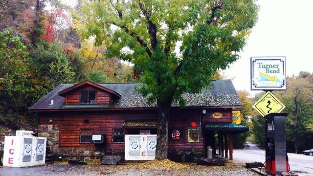
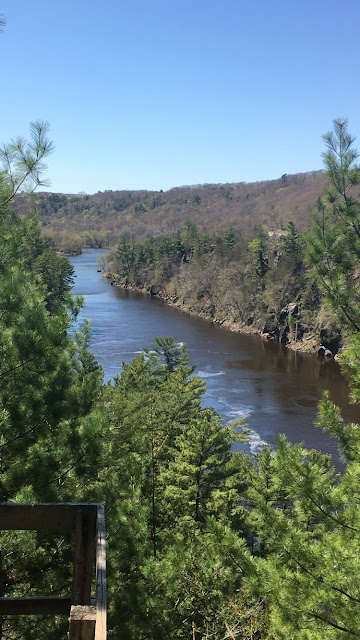
Click the link for map & step by step directions!  242 miles of cornering fun - plan at least 7 hours. Pig Trail - Oark - Hagarville - Deer- Ponca: 23, 215, 103, 123, 327, 74 This route leaves Eureka Springs, heads south on 23 to the Famed Pig Trail. Be sure to make a pit stop at Turner Bend Store for lots of cool mementos, cold drinks, bathroom stop, and photo ops.  Head back north a couple of miles to 215 to the east. This road follows the river, passing by campgrounds, hiking trails, and various picturesque stops. Then head south on 103 through Oark. Stop and check out the old school Oark gas station and store. Then meander your way to Hagersville, where you will then head north on 123. One of my faves - it has sweepers, switchbacks, a few 10 mph hairpins (if that). Then hit 7 to 327 - there are a variety of alternate roads you could take to get the same place - 7 to Jasper is great, 123 is great.... lots of options!  In Jasper, head west on 74 - another fun twisty wit

Ride Eureka Springs to Artist Point to Mount Magazine 298 miles, 6 hours+

Image
While the route is 298 miles and says it takes 6 hours, you will definitely want to stop at Artist Point (amazing views and a little store on site) and Mount Magazine (hiking, views, walking, amazing!)! Click here for a step by step map: Eureka Springs to Artist Point to Mount Magazine Map Mount Magazine Views Expanded map link: https://www.google.com/maps/dir/Eureka+Springs,+AR/Harris,+AR/Artist+Point,+AR/Havana,+AR/Mount+Magazine+Scenic+Byway,+Paris,+AR/Eureka+Springs,+AR/@35.7399536,-94.0631503,8.75z/data=!4m43!4m42!1m10!1m1!1s0x87ced2b619b8c8d7:0xe792bb3e4a53db56!2m2!1d-93.7379711!2d36.4011825!3m4!1m2!1d-93.782513!2d36.1140529!3s0x87c94c81777afbc3:0xe1c6b386dc1a401b!1m5!1m1!1s0x87c942b63d468969:0x8adeae4b42a1789c!2m2!1d-94.049797!2d36.028038!1m5!1m1!1s0x87cbdc6411575327:0x9bd5d07678a164cb!2m2!1d-94.136963!2d35.71991!1m5!1m1!1s0x87cc890e4a4862a9:0xb06786074011cce5!2m2!1d-93.529634!2d35.1112011!1m5!1m1!1s0x87cc7975a718a95d:0xb321b9ef4be90c15!2m2!1d-93.6863032!2d35.

Twin Cities - Western Loop with Biker Bar Stop: 100 Miles, 2.5 hours without stops

Image
Minneapolis - Maple Grove - Hanover - Rockford -Delano - Watertown - Spring Park - Victoria (Floyd's Bar)- Minnetonka - Minneapolis        100 Miles, 2.5 hours without stops Click Here to see the Route Details

AR: Eureka Springs SE Route (312 miles, 7 hrs) Roads: 201, 341, 14, 254, 16, & 123

Image
Eureka Springs - Mtn Home - Big Flat -Tilly - Western Grove Route 312 Miles/7 hours    Click the link for the step by step route!  Includes great twisty roads: 201, 341, 14, 254, 16, 123 https://www.google.com/maps/dir/Eureka+Springs,+AR/Yellville,+AR/Big+Flat,+AR/Leslie,+AR/Tilly,+AR/Sand+Gap,+AR/Western+Grove,+AR/Eureka+Springs,+AR/@36.0621942,-93.4550195,9.25z/data=!4m55!4m54!1m5!1m1!1s0x87ced2b619b8c8d7:0xe792bb3e4a53db56!2m2!1d-93.7379711!2d36.4011825!1m10!1m1!1s0x87ce161cb7b0e7b1:0xf0bc5db704a10ddc!2m2!1d-92.6848876!2d36.2261815!3m4!1m2!1d-92.3541426!2d36.1712036!3s0x87d1e6ed450e33ff:0xc24260309cd9107b!1m5!1m1!1s0x87d1fc43e1189e93:0x7041b6d32a615919!2m2!1d-92.4043257!2d36.005073!1m5!1m1!1s0x87cdfc393e4154a1:0x1a65fe8494fbdbde!2m2!1d-92.5579397!2d35.8303543!1m5!1m1!1s0x87cddcc6742b7671:0x3642d641762aeea6!2m2!1d-92.8329458!2d35.7200784!1m5!1m1!1s0x87cdd2b510f1099d:0x80093e1511e65d76!2m2!1d-93.0960078!2d35.7209134!1m5!1m1!1s0x87ce6596f47b04bf:0x7dd513d317544023!2m2!1d-92.9

One of my many, many on and off road dream routes in Colorado

Image
           One of my many, many on and off road dream routes in Colorado  (There are sooo many in CO!!) Gold Belt Scenic Byway – AKA Shelf Road and its siblings! Gold Belt Scenic Byway is a journey through Colorado’s former mining country. It offers breathtaking scenery that you won't find anywhere else. It is l ocated in southern Colorado and is 131-mile long.  Some parts of the route are, naturally, unpaved.   Along the way, there are many abandoned mines, buildings, and cool ghost towns.  There are lots of viewpoints and stops for great photo ops.  The road offers top notch scenery and views - but beware as some portions are particularly unforgiving with the roads are narrow and rugged in places. The byway contains many roads (below info taken from greatest roads website): Phantom Canyon Road : It connects Cañon City and Victor through Phantom Canyon. It features one-way tunnels, narrow gaps and a red curved bridge to master. The road has two tunnels and thre

A ride to, and a hike around, beautiful Interstate Park (Wisconsin side)

Image
Interstate Park - well worth a stop!!! Located on the Wisconsin side of the MN - WI border at Taylor's Falls. The MN side looks to have more established hiking 'trails', complete with guardrails and paved walkways. Not true on the Wisconsin side. While there are a few areas on the WI side that are flat - the only real walkways I saw were located well into the rock bluffs and only to guide people away from the ledge. There are several miles of trails on both the MN and WI side though, so I could be very wrong. Don't take my word for it - go explore!!! (Map at bottom of post)   The road into Interstate Park, the Wisconsin side, it just as enjoyable as the many trails to explore   Tons of trails - some flat, some rocks, some quite steep, others quick and easy - all have great views      But I safely made it out to the edge for the most amazing view!!!    Needless to say, I stuck out quite a bit in my 'hiking gear' - espec

My Epic April Fool's Day Prank!!!!

Image
I've never really done a REAL April Fools Day joke on anyone, aside from the usual one-liners. But this year, I happened to wake up in the middle of the night, unable to sleep, and was scrolling through Pinterest looking for who knows what ideas at 2am... when I saw it!!! An epic April Fools' Day Prank on my roomie - for after she got home from working her night shift!    It was a LOT of work stuffing enough clothing into the legs to make it look like a person who has been in quarantine for a month!!! But the final product.. of THIS part of the prank, turned out great!  Wondering how she was actually going to FIND 'me', I set a few alarms on my old phone and set the phone in 'my' back pocket.. And then I waited.. laying under a strategically placed heap of sheets, waiting to capture the moment. It took her forever - I had to reset alarms 3 times, but then she was making her way up the stairs and I just hid.. and waited for her to find 'me'

Every year the bestie & I trade 2 wheels for water - Jet ski shenanigans!

Image
Flashback Thursday!!!  The tale end of the summer means Annual Bestie Road Trip, Sans motorcycles, to Sortie - where hundreds of jet skiers come to show off their moves and have a good time! Love looking through these pictures!!  We hop in the wake boat and use our best photography skills to catch the stunts - its SO fun!!!! There is a reason the folks wear full face helmets on a jetski!  Beware RiVer Rocks - one hour after arrival, sliced my foot open in the river and well....I didn't want to miss out on the entire rest of the weekend, so I used a temporary fix! Not always the best ideas!!!   Putting my foot in the air to get the blood flow back to my leg LOL    (We have to take a vehicle to carry camping gear, food, coolers, and because the drive home is usually painful lol...but at least there is a sunroof!!)